We’ve been cautious about coming on board with the “Outbreak” messaging concerning the upcoming event Monday. For me, one reason is because I was wrong a couple of weeks ago when I went out on the outbreak limb early. But with SPC and the four NWS offices most involved in the enhanced risk area using either the terms “classic severe weather setup” or “outbreak,” I’m confident enough to start talking in that vein too.
What is a Classic Severe Weather Setup?
This morning’s Topeka Area Forecast Discussion (AFD) has as concise a treatment of the “classic” setup as I’ve seen in a while:
[A] deep upper low becomes negatively tilted over the Central Plains. As a developing lee cyclone pulls deep moisture northward, a dryline will become established across central Kansas, eventually becoming overtaken by a cold front. This is a classic setup for severe weather, with a potent combination of strong effective shear (40-50 kts) and moderate to strong ML CAPE (2000-3500 J/kg) ahead of a dynamic system. The most likely scenario is for supercells to develop along the dryline during the afternoon hours, moving northeast and gradually growing upscale into the evening across eastern Kansas.
Topeka, KS AFD issued 4:20am Saturday, referencing the Monday event
So let’s parse that — a review for many, but it’s always good to reiterate the meanings from time to time.
Deep Upper Low
This upper-level feature isn’t a direct cause of the concern for Monday. However, given its strength and positioning (well north of Kansas), the additional atmospheric components of the low (the cold front and dry line, as well as the Gulf moisture it draws northward due to its strength), the deep low is important to this discussion.
Negatively-tilted
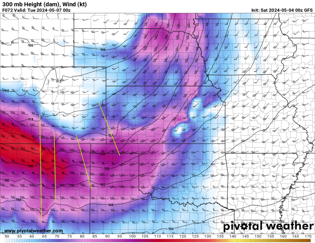
This means the trough (think of it as a front aloft, but that’s not completely accurate) is oriented from the northwest to the southeast. This will show up in some of the upper-air graphics I show later. This type of trough is often associated with outbreaks of severe weather, including significant precipitation and strong winds.
Lee cyclone
This is a low pressure area that develops in the lee side of the Rockies [more explanation from Wikipedia]. Wind on the large scale moves generally west to east. When it gets pushed up on the west side of the Rockies, the wind creates a lower pressure just east of the mountains. It’s quite a lot like the physical process that creates lift on an airplane wing. The air flowing faster over the curved upper part of the wing creates lift on the under side of the wing due to the lower pressure it induces in the slower-moving air on the straighter, underside of the wing.
Deep moisture
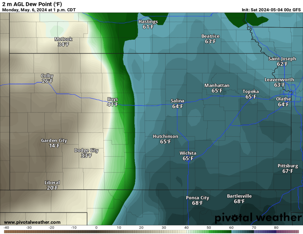
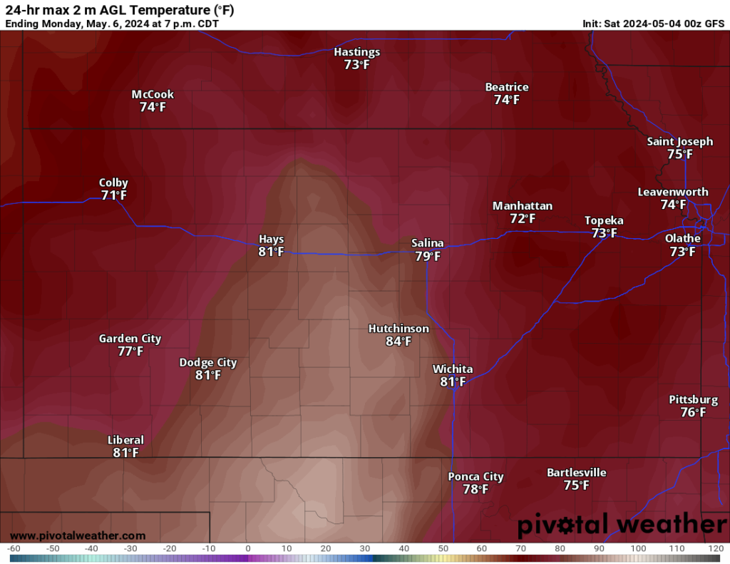
This is a casual reference both to the amount of moisture and how high in the atmosphere the moist air goes. Moist air is less stable than dry air. Models this morning are showing dew points on Monday afternoon in the mid-60’s well north into Kansas. With highs only forecast 10-15 degrees above the dew point, this will lead to very humid air and a lot of latent energy for storms to use. {Tap on either image to enlarge)


As mentioned, “deep” refers to how high up the moist air goes. Forecast maps for the 7pm time frame Monday show relative humidity as high as 95% at the 5.67 km (18,000 foot) level (over 3 miles up). That’s very deep moisture.
Dryline
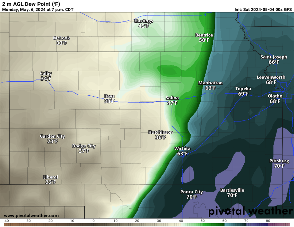
The dividing line between the moist and dry air. On the top image the dry line at 1pm is still somewhat diffuse, taking 20-30 miles to go from the 60’s to the 30’s. That will sharpen with time:

Now that same 60’s to 30’s transition occurs in about 12 miles.
Effective Shear
(Description produced by AI) Effective shear refers to the combination of both speed shear and directional shear in the atmosphere. It is a critical factor in the development of severe thunderstorms, tornadoes, and other severe weather phenomena.
Speed Shear: This type of shear occurs when there is a change in wind speed with height. For example, a wind speed of 20 mph at 10,000 feet increasing to 50 mph at 20,000 feet.
Directional Shear: This type of shear occurs when there is a change in wind direction with height. For example, southeasterly winds at the surface and southwesterly winds aloft.
Effective shear is often considered important for tornado development because it creates an area of rotation, known as a mesocyclone, which can eventually touch the ground and become a tornado.
Bottom line: 40-50 knots (46-57mph) is an effective shear value worth paying attention to in May.
MLCAPE
This is a measure of the Convective Available Potential Energy (CAPE, see Wikipedia for more details) available in the lowest layers of the atmosphere — in this case, between the surface and 10,000 feet, give or take. 2000-3500 j/kg (Joules per kilogram) is a healthy amount of CAPE for this time of year. Although I understand the concept — a measure of the ability of the atmosphere to lift a parcel (unit) of air weighing 1 kilogram a distance of one meter — I am having trouble translating it accurately into a concrete thing. The CAPE it takes to cause a storm varies by time of year — for early May this is, as I said above, a healthy amount of CAPE.
Bottom-line Translation
We have sufficient energy (MLCAPE of 2000-3500 j/kg), shear (twist, 40-50 knots), and instability (represented by the moisture in the air) for storms. We have a dry line, which serves as a wedge in the atmosphere, giving the units of air at the surface a push upward. It’s much like having a helium balloon and instead of holding down or simply releasing it, you give it a push so it rises faster.
Looking in More Detail
I’ll dive more deeply into this in our members-only discussion, but I did want to show a couple of model graphics that illustrate things like the negatively-tilted trough. In these graphics, a trough is shown by kinks in the heavier black lines. I’ve approximated the locations of what are called “shortwave” troughs, where there are somewhat-aligned kinks in the heavier lines. These shortwaves are partly responsible for giving storms the “kick” needed to grow vertically. (Note: I’ve not drawn green lines for all the shortwave troughs, and there may be some disagreement as to whether one of them I identified is really meaningful.)

Bottom Line
This outlook is meant to be educational and more of a heads-up than anything. Given the level of activity and potential risk, I want to make sure our whole team has the chance to weigh in on our “official” outlook that will discuss the storm evolution and our best take for the forecast hot spots Monday. Look for that later today. I wanted to get this out early today to give you a heads-up on the risk, which does look to be significant. Please use today and tomorrow to prepare…I’ll have some practical steps coming up later this morning.
