Bottom Line Up Front

Risk Summary
Overall Peak Risk

Selected Communities

SPC Outlook Details
Overall (Categorical) Risk

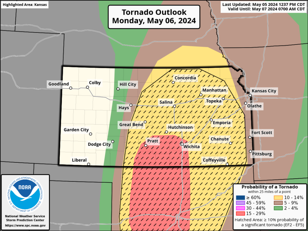
Tornado Probability
Any Tornado

EF-2 or Greater Damage (Hatched Area)
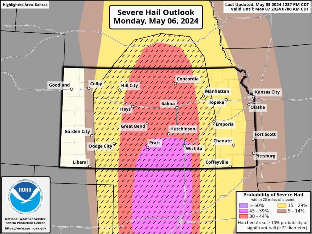
Hail Probability
Hail 1″ or larger

Hail larger than 2″ (Hatched Area)
Damaging Wind
Wind 58mph+

Wind 70mph+ (Hatched Area)

SPC Discussion
Numerous severe thunderstorms are expected to develop and move eastward Monday afternoon through Monday night across parts of the southern/central Plains. Multiple strong/potentially long-track tornadoes, very large to giant hail, and severe/damaging winds all appear likely.
SPC Day 2 Discussion Released 12:37pm Sunday
NWS Office Latest Thoughts
(Note: These are the offices in which we participated on Emergency Manager/Partner Conference Calls this afternoon. We aren’t leaving out other offices for any other reason than we were not informed of their conference calls.)
Dodge City

The discussion in the call noted the early start, with some storms firing along the dryline on US-83 north of Garden City by as early as 10 am and moving east as a small line gradually expanding in size and strength as it moves into better air east of Dodge City. They also showed this graphic, which was generated this morning based on model runs showing the position of the main weather features in the mid-afternoon.

Their concern for the highest probability of the highest impacts starts about 4pm in the Greensburg, Coldwater, Pratt or Medicine Lodge vicinity. As the night progresses the storms strengthen as they move into Wichita’s warning area.
Wichita

Wichita sees two scenarios: One is a line that develops in central Kansas mid-afternoon and would affect the Great Bend vicinity as it starts a line which will zipper north and south and push into the area between K-14 and I-135. A line would primarily produce a large hail risk, but there may be embedded supercells which would keep the tornado risk meaningful as well. The potential for softball-sized hail was mentioned, but we believe that potential is more from the individual supercells which may develop ahead of the line.
The second scenario would be that supercells would develop in Oklahoma and move northeast into the area just east of the current moderate risk, so perhaps as far east as Coffeyville.

Model Data
I’m not going to do a deep dive on the model data this go-round, as we’re getting closer we’re getting into the “it’s going to do what it’s going to do” phase of preparation and the differences and subtleties between the models become less relevant. So all I’m sharing this time is forecast radar loops for several models, showing their prediction of radar appearance starting at 7am Monday and running until the storms exit stage right Tuesday morning. You may need to click or tap each for it to loop.


Our Take
While the likelihood of a severe weather outbreak appears to be pretty high, there are a couple of potential factors which would tend to limit/reduce the hazards.
- Moisture return was mentioned by Wichita as a factor that could limit the storms. Given the humidity today, I’m finding that hard to buy into; I feel we’ll have enough moisture to get it done.
- Linear storm mode especially on the storms in central Kansas would reduce but not eliminate the strong tornado threat. It would also increase the straight line wind threat along with making hail more widespread and somewhat smaller, though still potentially damaging.
We see three potentials for strong, long-track tornadoes and giant hail:
- Any supercell that can develop ahead of the line of storms, especailly in south central Kansas, will have all the right stuff to work with.
- A tail-end Charlie (the south end of the line) will also have access to all the right components for high-end severe risks.
- Storms which move in from Oklahoma will likely already be producing a tornado. These would continue and perhaps strengthen as we get toward 7pm.
Unfortunately these potentials overlap in one region…the one highlighted quite well by the moderate risk area, which did not change from the morning to the afternoon Day 2 outlook except to move just a bit further north. I believe anyone in the orange area could see one or more strong, long-track tornadoes and hail to grapefruit size. In the red area, probabilities are higher. Approximate timing: west edge of the red area 3-4pm, east edge 7-9pm (when, unfortunately, it may be at its strongest). East of the red area may see storms coming in from Oklahoma that would likely be tornadic.